 https://finlandnaturally.com/wp-content/uploads/2024/11/konnevesi.jpg
687
1030
Antti Huttunen
https://finlandnaturally.com/wp-content/uploads/2020/06/fne-logo-vaaka-web.png
Antti Huttunen2024-11-13 12:30:052024-11-13 12:32:01Exploring the Kalaja Trail: A Scenic 4.6 km Hike in Etelä-Konnevesi National Park
https://finlandnaturally.com/wp-content/uploads/2024/11/konnevesi.jpg
687
1030
Antti Huttunen
https://finlandnaturally.com/wp-content/uploads/2020/06/fne-logo-vaaka-web.png
Antti Huttunen2024-11-13 12:30:052024-11-13 12:32:01Exploring the Kalaja Trail: A Scenic 4.6 km Hike in Etelä-Konnevesi National ParkEtelä-Konnevesi National Park
Konnevesi, Rautalampi
North Savo
From Smooth Rocks to the Labyrinths of the Archipelago
Etelä-Konnevesi National Park was established in the summer of 2014. The terrain of the national park is a dialogue between lake landscapes and majestic rock formations. In the western and northern parts, the landscape is dominated by open waters and expansive smooth rocks. In the south and east, there are labyrinthine archipelago, high hills, and fracture valleys.
The islands are the dominant element of Etelä-Konnevesi National Park. They offer almost endless experiences for travelers, whether you’re paddling, ice skating, skiing, or boating. Both the national park and its surroundings are excellent for day trips. For those with a sense of adventure, the national park area and nearby terrains offer plenty of interesting small sites, from rock paintings to memorial trees and caves.
Services
Dive into Nature from the Steps of a Cottage
A cottage is a good base for hikers. Dive into the embrace of beautiful nature in the morning, well-rested, and return in the evening to sleep sweet dreams after a wonderful trip.
Find and book cottages in Konnevesi here >>
Find and book cottages in Rautalampi here >>
The nearest services to the national park are in Rautalampi, where you can find, among other things, grocery and general stores, a pharmacy, gas stations, and restaurants. The locations of these services are marked on the accompanying map. In Konnevesi, you will also find shops, a pharmacy, and a gas station, among other amenities.
Trails in Etelä-Konnevesi National Park
First Time in Etelä-Konnevesi?
From a hiker’s perspective, the most interesting area is Enonniemi, which contains nearly half of the national park’s land area. There, you’ll also find parking areas serving those traveling on foot and the most significant attraction, Kalajanvuori.
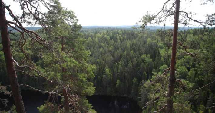
Kalajanvuori’s summit rises slightly over 210 meters above sea level. From the top, far-reaching views open over Etelä-Konnevesi and Hankavesi, which many have compared to national landscapes. A roughly five-kilometer-long trail circles the mountain, which has long been popular among locals. It will also be part of the developing trail network of the national park.
The majority of the national park’s islands are very barren. The vegetation has many similarities with that of Forest Lapland. On the largest islands, the laughter of the willow ptarmigan surprises the traveler. Lapland is also present in Etelä-Konnevesi through place names. On the map, you can find, among others, Lapinsalo (Lapland forest).
Accessible Trails
Vuori-Kalaja Has an Accessible Trail
- There is a gate on the road leading to the Vuori-Kalaja disabled parking area. You can get the key to the gate from Törmälä.
- From the parking area, there’s a 90-meter accessible trail to the Vuori-Kalaja campfire site.
- The lean-to shelter, campfire site, and toilet are accessible.
- You will need an assistant on the trail.
Loop Trails
- Loukkuvuori Loop (2.8 km) traverses challenging rugged landscapes and starts from Enonniemi. You can reach the starting point of the route by boat, paddling, or, for example, by bicycle; there is no access by car.
- Kalaja Trail is a 4.6 km long nature trail that climbs to Kalajanvuori, offering some of the most breathtaking views in the national park. A great choice for first-timers, but due to its elevation changes, not an entirely easy circuit. Start from the Kalaja parking area or from Törmälä. Read more.
- Three Mountains Hike is a 16-kilometer-long circuit through rugged elevation changes, old forests, and beautiful lakeside landscapes. Start from the Kalaja parking area or from Törmälä.
Paddling
There are numerous paddling routes in the area. Consider at least these!
- Kivisalmi Loop, 3 km
- Käpynän Ukko Loop, 4.3 km
- Rajasaari Loop, 8 km
- Toussunlinna Loop, 18.5 km
- Konnevesi Rapids Route, 22 km
How to get there
Easiest to Arrive by Own Car
It’s simplest to reach Etelä-Konnevesi National Park by your own car. If you can bring along a bicycle, kayak, or canoe, even better—you’ll be able to move around diversely in this park of waters, mountains, and forests.
By car
Below is a list of parking areas and their addresses:
Kivisalmi, Parking Area and Boat Launch, Rautalammintie 1935
Häyrylänranta, Parking Area and Boat Launch, Satamatie, Konnevesi
Törmälä Course Center Parking Area, Konnekoskentie 552
Kalaja Parking Area Törmälän metsätie 136, Rautalampi (accessible but behind a gate. You can get the key to the gate from Törmälä.)
By public transport
- You can reach as close as Konnevesi and Rautalampi by bus. There is no bus line to the national park area.
- Sisä-Savon Tilataksi E.Lindroos Oy (+358 40 765 3398) operates in the area, and it’s possible to order transportation to the national park from them.
Our stories from Etelä-Konnevesi
https://finlandnaturally.com/wp-content/uploads/2024/11/konnevesi.jpg
687
1030
Antti Huttunen
https://finlandnaturally.com/wp-content/uploads/2020/06/fne-logo-vaaka-web.png
Antti Huttunen2024-11-13 12:30:052024-11-13 12:32:01Exploring the Kalaja Trail: A Scenic 4.6 km Hike in Etelä-Konnevesi National Park